
Quend Plage les Pins topographic map
Interactive map
Click on the map to display elevation.
About this map
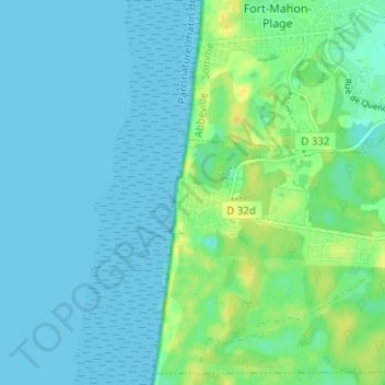
Name: Quend Plage les Pins topographic map, elevation, terrain.
Average elevation: 6 m
Minimum elevation: -1 m
Maximum elevation: 22 m
Other topographic maps
Click on a map to view its topography, its elevation and its terrain.
Routhiauville
France > Hauts-de-France > Somme > Quend
Routhiauville, Quend, Abbeville, Somme, Hauts-de-France, France métropolitaine, 80120, France
Average elevation: 7 m
Monchaux
France > Hauts-de-France > Somme > Quend
Monchaux, Quend, Abbeville, Somme, Hauts-de-France, France métropolitaine, 80120, France
Average elevation: 6 m