
Santo Domingo Oeste topographic map
Interactive map
Click on the map to display elevation.
About this map
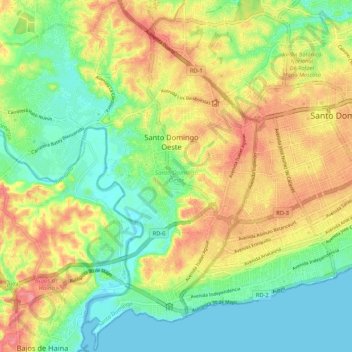
Name: Santo Domingo Oeste topographic map, elevation, terrain.
Location: Santo Domingo Oeste, Santo Domingo, D.R. (18.41308 -70.07365 18.51254 -69.96763)
Average elevation: 34 m
Minimum elevation: 0 m
Maximum elevation: 76 m
Other topographic maps
Click on a map to view its topography, its elevation and its terrain.