
Shanxi topographic map
Interactive map
Click on the map to display elevation.
About this map
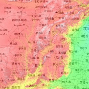
Name: Shanxi topographic map, elevation, terrain.
Location: Shanxi, China (34.58407 110.21954 40.74496 114.56551)
Average elevation: 936 m
Minimum elevation: 7 m
Maximum elevation: 2,872 m
Shanxi is located on a plateau made up of higher ground to the east (Taihang Mountains) and the west (Lüliang Mountains) and a series of valleys in the center through which the Fen River runs. The highest peak is Mount Wutai (Wutai Shan) in northeastern Shanxi with an altitude of 3,058 m. The Great Wall of China forms most of the northern border with Inner Mongolia. The Zhongtiao Mountains run along part of the southern border and separate Shanxi from the east–west part of the Yellow River. Mount Hua is to the southwest.
Other topographic maps
Click on a map to view its topography, its elevation and its terrain.
Qiaotou Town
China > Guangdong Province > Dongguan
Qiaotou Town, Dongguan, Guangdong Province, China
Average elevation: 13 m
Jinniu District
Jinniu District, Chengdu, Wuhou, Sichuan, China
Average elevation: 512 m
Tai Po
China > Hong Kong > Tai Po District
Tai Po, Tai Po District, New Territories, Hong Kong, China
Average elevation: 155 m
Macau
China > Macau > São Lourenço
Macau, São Lourenço, Municipality of Macau, Macau, 519020, China
Average elevation: 17 m
Luohu District
Luohu District, Shenzhen, Guangdong Province, 518000, China
Average elevation: 74 m
Qingyuan City
Qingyuan City, Guangdong Province, China
Average elevation: 349 m
Lhoka
China > Tibet > Tsetang Township
Lhoka, Tsetang Township, Nêdong District, Lhoka, Tibet, China
Average elevation: 4,148 m
Heihe
China > Heilongjiang > 幸福乡
Heihe, 幸福乡, Aihui District, Heihe City, Heilongjiang, 164300, China
Average elevation: 174 m
Chengguan District
Chengguan District, Lhasa, Tibet, 850000, China
Average elevation: 4,325 m
Ngawa Tibetan and Qiang Autonomous Prefecture
Ngawa Tibetan and Qiang Autonomous Prefecture, Sichuan, China
Average elevation: 3,542 m
Bishan District
Bishan District, Chongqing Main City Metropolitan Area, Chongqing, China
Average elevation: 344 m
Yushan
China > Jiangxi > Yushan County > Bingxi Subdistrict
Yushan, Bingxi Subdistrict, Yushan County, Shangrao, Jiangxi, China
Average elevation: 184 m
Guangzhou City
Guangzhou City, Guangdong Province, China
Average elevation: 98 m
Yiti
China > Sichuan > Ebian Yi Autonomous County
Yiti, Ebian Yi Autonomous County, Leshan City, Sichuan, China
Average elevation: 1,833 m
Maogang
China > Songjiang District > Maogang
Maogang, Songjiang District, Shanghai, China
Average elevation: 4 m
Islands District
Islands District, New Territories, Hong Kong, China
Average elevation: 36 m
Yanluo Sub-district
China > Guangdong Province > Bao'an District > Yanluo Sub-district
Yanluo Sub-district, Bao'an District, Shenzhen, Guangdong Province, 518100, China
Average elevation: 40 m