
Meudon topographic map
Interactive map
Click on the map to display elevation.
About this map
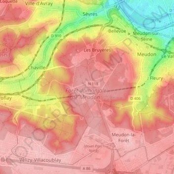
Name: Meudon topographic map, elevation, terrain.
Average elevation: 136 m
Minimum elevation: 26 m
Maximum elevation: 187 m
Other topographic maps
Click on a map to view its topography, its elevation and its terrain.
Meudon
France > Île-de-France > Hauts-de-Seine > Meudon > Meudon
Meudon, Boulogne-Billancourt, Hauts-de-Seine, Île-de-France, France métropolitaine, 92190, France
Average elevation: 107 m