
Isla Fernandina topographic map
Interactive map
Click on the map to display elevation.
About this map
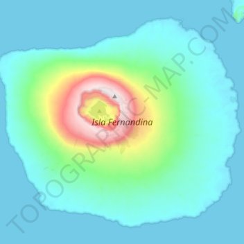
Name: Isla Fernandina topographic map, elevation, terrain.
Location: Isla Fernandina, Cantón Isabela, Galápagos, Ecuador (-0.50703 -91.66144 -0.26188 -91.37671)
Average elevation: 201 m
Minimum elevation: 0 m
Maximum elevation: 1,478 m
Other topographic maps
Click on a map to view its topography, its elevation and its terrain.