
Utah County topographic map
Interactive map
Click on the map to display elevation.
About this map
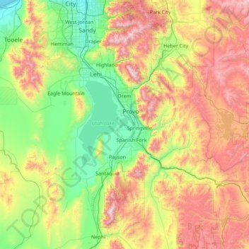
Name: Utah County topographic map, elevation, terrain.
Location: Utah County, Utah, United States (39.77736 -112.21283 40.57791 -110.85765)
Average elevation: 2,062 m
Minimum elevation: 1,283 m
Maximum elevation: 3,581 m
Utah Valley lies at the center of the county, lined by the mountains of the Wasatch Range on the east. Utah Lake occupies a large part of the valley. The elevation ranges from 4,487 feet (1,368 m) above sea level at the lake to 11,928 feet (3,636 m) at the peak of Mount Nebo.
Other topographic maps
Click on a map to view its topography, its elevation and its terrain.
Zion National Park
United States > Utah > Washington County
Zion National Park, Washington County, Utah, United States
Average elevation: 1,877 m
Park City
United States > Utah > Summit County > Park City
Park City, Summit County, Utah, 84060, United States
Average elevation: 2,315 m
Salt Lake County
United States > Utah > Salt Lake County
Salt Lake County, Utah, United States
Average elevation: 1,811 m
Provo
United States > Utah > Utah County
Provo, Utah County, Utah, United States
Average elevation: 1,728 m