
Nowy Targ topographic map
Interactive map
Click on the map to display elevation.
About this map
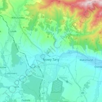
Name: Nowy Targ topographic map, elevation, terrain.
Location: Nowy Targ, Nowy Targ County, Lesser Poland Voivodeship, Poland (49.44404 19.98251 49.53448 20.10343)
Average elevation: 676 m
Minimum elevation: 567 m
Maximum elevation: 1,135 m
According to the Köppen climate classification, Nowy Targ straddles the border of the Warm Summer Continental (Dfb) and Subarctic (Dfc) climates, with most of the city falling in the Dfb group. The Dfc climate is only found above 800 meters (2,600 ft)of elevation within Nowy Targ.