
Deschutes County topographic map
Interactive map
Click on the map to display elevation.
About this map
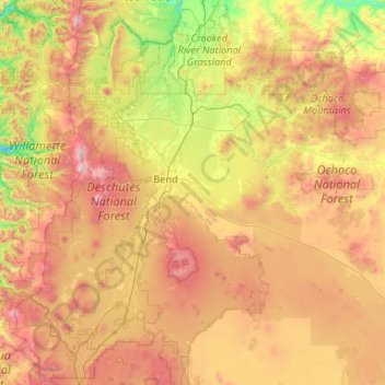
Name: Deschutes County topographic map, elevation, terrain.
Location: Deschutes County, Oregon, United States (43.61106 -122.00251 44.39352 -119.89658)
Average elevation: 1,324 m
Minimum elevation: 423 m
Maximum elevation: 3,082 m
Other topographic maps
Click on a map to view its topography, its elevation and its terrain.
Beaverton
United States > Oregon > Washington County
Beaverton, Washington County, Oregon, United States
Average elevation: 106 m
Lazarus Island
United States > Oregon > Tillamook County > Wheeler Heights
Lazarus Island, Wheeler Heights, Tillamook County, Oregon, United States
Average elevation: 43 m
Hood River County
Hood River County, Oregon, United States
Average elevation: 860 m
Clackamas County
Clackamas County, Oregon, United States
Average elevation: 660 m