
Hartford County topographic map
Interactive map
Click on the map to display elevation.
About this map
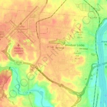
Name: Hartford County topographic map, elevation, terrain.
Location: Windsor Locks, Hartford County, Connecticut, 06096, USA (41.89827 -72.69675 41.94821 -72.61419)
Average elevation: 36 m
Minimum elevation: 0 m
Maximum elevation: 62 m
Other topographic maps
Click on a map to view its topography, its elevation and its terrain.
The Plans
USA > Connecticut > Norwalk
The Plans, Norwalk, Fairfield, Connecticut, USA
Average elevation: 0 m
Major Island
Major Island, New London County, Connecticut, USA
Average elevation: 16 m
Lions Head
Lions Head, Litchfield County, Connecticut, 06968, USA
Average elevation: 403 m
Hartford
USA > Connecticut > Hartford
Hartford, Hartford County, Connecticut, USA
Average elevation: 23 m
Barn Island
Barn Island, New London County, Connecticut, 06379, USA
Average elevation: 33 m