
Putney topographic map
Interactive map
Click on the map to display elevation.
About this map
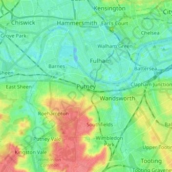
Name: Putney topographic map, elevation, terrain.
Location: Putney, Greater London, England, SW15 1RG, United Kingdom (51.42255 -0.25675 51.50255 -0.17675)
Average elevation: 18 m
Minimum elevation: -8 m
Maximum elevation: 59 m
Putney Heath is around 400 acres (160 hectares) less the nascent A3 road in size and rises to 45 metres (148 ft) above sea level. Because of its elevation, from 1796 to 1816 Putney Heath hosted a station in the shutter telegraph chain, which connected the Admiralty in London to its naval ships in Portsmouth. One of 10 signal stations with telescopes making observation of the next station's signal, a message could be sent from the Admiralty to Portsmouth within 15 minutes. This was replaced by a semaphore station, which was part of a semaphore line that operated between 1822 and 1847.
Other topographic maps
Click on a map to view its topography, its elevation and its terrain.
London
United Kingdom > England > London
London, Greater London, England, SW1A 2DX, United Kingdom
Average elevation: 42 m
London
London, Greater London, England, United Kingdom
Average elevation: 66 m
Bristol
United Kingdom > England > City of Bristol
Bristol, City of Bristol, West of England, England, United Kingdom
Average elevation: 55 m
Cambridge
United Kingdom > England > Cambridge
Cambridge, Cambridgeshire, East of England, England, United Kingdom
Average elevation: 18 m
Sheffield
Sheffield, South Yorkshire, England, United Kingdom
Average elevation: 168 m
Greater Manchester
Greater Manchester, England, United Kingdom
Average elevation: 141 m
South East England
South East England, England, United Kingdom
Average elevation: 69 m
Wimbledon
Wimbledon, Greater London, England, SW19 7NL, United Kingdom
Average elevation: 26 m
Wirral
Wirral, Liverpool City Region, England, United Kingdom
Average elevation: 21 m
Greater London
Greater London, England, United Kingdom
Average elevation: 66 m
Hull
United Kingdom > England > Kingston upon Hull
Hull, Kingston upon Hull, England, HU1 3RJ, United Kingdom
Average elevation: 21 m
Leeds
United Kingdom > England > Leeds
Leeds, Yorkshire and the Humber, England, LS1 6AL, United Kingdom
Average elevation: 94 m
East Riding of Yorkshire
East Riding of Yorkshire, England, United Kingdom
Average elevation: 30 m
Portishead
United Kingdom > England > Portishead
Portishead, North Somerset, South West England, England, BS20, United Kingdom
Average elevation: 26 m
Birmingham
Birmingham, West Midlands Combined Authority, England, United Kingdom
Average elevation: 138 m
Leicester
United Kingdom > England > Leicestershire
Leicester, Leicestershire, England, LE1 5YA, United Kingdom
Average elevation: 109 m
Torquay
United Kingdom > England > Torbay
Torquay, Torbay, England, TQ1 1TR, United Kingdom
Average elevation: 31 m
Bagby
United Kingdom > England > North Yorkshire
Bagby, North Yorkshire, England, United Kingdom
Average elevation: 48 m
Grimston
United Kingdom > England > Norfolk > King's Lynn and West Norfolk
Grimston, King's Lynn and West Norfolk, Norfolk, England, PE32 1AB, United Kingdom
Average elevation: 24 m
Crewe
United Kingdom > England > Crewe
Crewe, Cheshire East, North West England, England, CW1 2HU, United Kingdom
Average elevation: 53 m
Norwich
United Kingdom > England > Norfolk
Norwich, Norfolk, England, United Kingdom
Average elevation: 28 m
Newcastle upon Tyne
Newcastle upon Tyne, North of Tyne, England, United Kingdom
Average elevation: 57 m
Liverpool
Liverpool, Liverpool City Region, England, United Kingdom
Average elevation: 26 m
Brighton
United Kingdom > England > Brighton and Hove
Brighton, Brighton and Hove, England, United Kingdom
Average elevation: 64 m
Nottingham
United Kingdom > England > Nottinghamshire
Nottingham, England, United Kingdom
Average elevation: 56 m
Somerset
Somerset, South West England, England, United Kingdom
Average elevation: 87 m
Chichester
United Kingdom > England > Chichester
Chichester, West Sussex, South East, England, United Kingdom
Average elevation: 57 m
Poole
United Kingdom > England > Bournemouth, Christchurch and Poole > Merley
Poole, Merley, Bournemouth, Christchurch and Poole, England, United Kingdom
Average elevation: 23 m
Peterborough
United Kingdom > England > City of Peterborough
Peterborough, City of Peterborough, Cambridgeshire and Peterborough, England, PE1 1XH, United Kingdom
Average elevation: 17 m
Eastnor Deer Park
United Kingdom > England > Herefordshire > Eastnor > Wayend Street
Eastnor Deer Park, A438, Wayend Street, Eastnor, Herefordshire, England, HR8 1EW, United Kingdom
Average elevation: 134 m
Kent
United Kingdom > England > Sevenoaks
Kent, Beechenlea Lane, Swanley, Sevenoaks, Kent, South East, England, BR8 7PR, United Kingdom
Average elevation: 37 m
Lincolnshire
Lincolnshire, East Midlands, England, United Kingdom
Average elevation: 28 m
North Yorkshire
North Yorkshire, Yorkshire and the Humber, England, United Kingdom
Average elevation: 153 m
Retford
United Kingdom > England > Nottinghamshire > Bassetlaw
Retford, Bassetlaw, Nottinghamshire, England, DN22 6DR, United Kingdom
Average elevation: 31 m
Skipton
United Kingdom > England > Skipton
Skipton, North Yorkshire, Yorkshire and the Humber, England, BD23 1DU, United Kingdom
Average elevation: 201 m
Bath
United Kingdom > England > Bath and North East Somerset
Bath, Bath and North East Somerset, West of England, England, United Kingdom
Average elevation: 100 m
Harrogate
United Kingdom > England > North Yorkshire
Harrogate, North Yorkshire, England, United Kingdom
Average elevation: 131 m
Oxford
United Kingdom > England > Oxfordshire
Oxford, Oxfordshire, England, United Kingdom
Average elevation: 81 m