
Miranda State topographic map
Interactive map
Click on the map to display elevation.
About this map
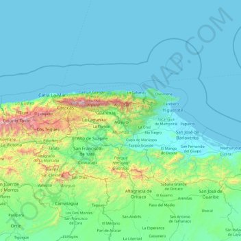
Name: Miranda State topographic map, elevation, terrain.
Location: Miranda State, Venezuela (9.93715 -67.24590 10.87641 -65.42090)
Average elevation: 255 m
Minimum elevation: 0 m
Maximum elevation: 2,666 m
The hydrography of Miranda State is characterized by the short course and low flow of its rivers, with the exception of Tuy. This characteristic, combined with the settlement of the largest mass of population in the country, gives its rivers great significance as sources of water for urban consumption. The Tuy River, with a length of 250 km, rises at an altitude of 2 100 m, on the southern flank of the Litoral mountain range, flows eastwards through the Abra de Tácata to the Tuy and Barlovento valleys, and flows into the Caribbean Sea through the Paparo mouth. The El Jarillo River and the Aguas Frías and La Negra streams, tributaries of the Tuy on the left bank, have been dammed, near the Teques, in the Agua Fría reservoir, while the Ocumare, was dammed near Ocumare del Tuy, in the Ocumarito reservoir. The best known tributary is the Guaire River. On the right bank, the Tuy receives the Taguaza, Taguacita and Cuira rivers. Other important rivers are the Guarenas, Rio Grande or Caucagua, Capaya, El Guapo, Pacairigua, El Curiepe and Cúpira.
Other topographic maps
Click on a map to view its topography, its elevation and its terrain.
Morrocoy
Venezuela > Falcon State > Municipio Silva
Morrocoy, Parroquia Tucacas, Municipio Silva, Falcon State, Venezuela
Average elevation: 52 m
Cayo Sombrero
Venezuela > Falcon State > Municipio Silva
Cayo Sombrero, Parroquia Tucacas, Municipio Silva, Falcon State, Venezuela
Average elevation: 0 m
Cayo Sal
Venezuela > Federal Dependencies
Cayo Sal, Archipiélago Los Roques, Federal Dependencies, Venezuela
Average elevation: 0 m
Sector La Urbina
Venezuela > Miranda > La Urbina
Sector La Urbina, La Urbina, Municipio Sucre, Miranda, Región Capital, 1073, Venezuela
Average elevation: 924 m
Ciudad Guayana (Puerto Ordaz)
Venezuela > Bolivar State > Ciudad Guayana (Puerto Ordaz)
Ciudad Guayana (Puerto Ordaz), Parroquia Unare, Municipio Caroní, Bolivar State, 8050, Venezuela
Average elevation: 73 m
Municipio Baruta
Municipio Baruta, Miranda, Región Capital, Venezuela
Average elevation: 1,047 m
Parroquia Sucre
Venezuela > Capital District > Parroquia Sucre
Parroquia Sucre, Municipio Libertador, Capital District, Región Capital, 1030, Venezuela
Average elevation: 956 m
Parroquia San Cristobal
Venezuela > Anzoategui State > Parroquia San Cristobal
Parroquia San Cristobal, Distrito Bolívar, Anzoategui State, Venezuela
Average elevation: 101 m
Parroquia Sección Capital Gran Sabana
Venezuela > Bolivar State > Parroquia Sección Capital Gran Sabana
Parroquia Sección Capital Gran Sabana, Gran Sabana Municipality, Bolivar State, 8011, Venezuela
Average elevation: 744 m
Río Orinoco
Venezuela > Delta Amacuro State
Río Orinoco, Parroquia Juan Bautista Arismendi, Delta Amacuro State, Venezuela
Average elevation: 114 m
Los Castores
Venezuela > Cojedes > Los Castores
Los Castores, Distrito Tinaco, Cojedes, Venezuela
Average elevation: 442 m
Bourgoin (North) Glacier
Bourgoin (North) Glacier, Mérida, Municipio Libertador, Mérida, Venezuela
Average elevation: 4,395 m
Tucupita
Venezuela > Delta Amacuro State > Tucupita
Tucupita, Parroquia Monseñor Argimiro García, Municipio Tucupita, Delta Amacuro State, 6401, Venezuela
Average elevation: 5 m
San Antonio de los Altos
Venezuela > Miranda > San Antonio de los Altos
San Antonio de los Altos, Parroquia San Antonio de los Altos, Municipio Los Salias, Miranda, 1204, Venezuela
Average elevation: 1,002 m
Isla Margarita
Isla Margarita, Municipio Díaz, Nueva Esparta, Venezuela
Average elevation: 12 m
La Corona Glacier
La Corona Glacier, Mérida, Municipio Libertador, Mérida, Venezuela
Average elevation: 4,387 m
Caracas
Venezuela > Capital District > Caracas
Caracas, Municipio Libertador, Capital District, 1010-A, Venezuela
Average elevation: 858 m