
Frankfurt topographic map
Interactive map
Click on the map to display elevation.
About this map
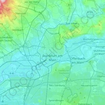
Name: Frankfurt topographic map, elevation, terrain.
Location: Frankfurt, Hesse, Germany (50.01535 8.47276 50.22714 8.80040)
Average elevation: 133 m
Minimum elevation: 89 m
Maximum elevation: 483 m
Other topographic maps
Click on a map to view its topography, its elevation and its terrain.
Bad Nauheim
Germany > Hesse > Bad Nauheim
Bad Nauheim, Wetteraukreis, Regierungsbezirk Darmstadt, Hesse, 61231, Germany
Average elevation: 175 m