
Southland District topographic map
Interactive map
Click on the map to display elevation.
About this map
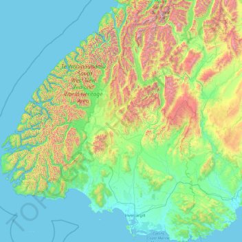
Name: Southland District topographic map, elevation, terrain.
Location: Southland District, Southland, New Zealand (-46.67550 166.42555 -44.25512 169.27947)
Average elevation: 439 m
Minimum elevation: -1 m
Maximum elevation: 2,753 m
Other topographic maps
Click on a map to view its topography, its elevation and its terrain.
Lake Tekapo
New Zealand > Canterbury > Mackenzie District
Lake Tekapo, Mackenzie District, Canterbury, New Zealand
Average elevation: 743 m
Havelock North
New Zealand > Hawke's Bay > Hastings District
Havelock North, Hastings District, Hawke's Bay, 4130, New Zealand
Average elevation: 45 m
Heathcote River
New Zealand > Canterbury > Christchurch City > Christchurch
Heathcote River, Christchurch, Christchurch City, Canterbury, New Zealand
Average elevation: 66 m
Queenstown
New Zealand > Otago > Queenstown-Lakes District
Queenstown, Queenstown-Lakes District, Otago, 9348, New Zealand
Average elevation: 592 m
Auckland
Auckland, Waitematā, Auckland, 1010, New Zealand
Average elevation: 32 m
Milford Sound
Milford Sound, Southland District, Southland, New Zealand
Average elevation: 304 m
Cowes Bay
New Zealand > Auckland > Waiheke
Cowes Bay, Waiheke, Auckland, New Zealand
Average elevation: 34 m
Chatham Islands
Chatham Islands, Kaiwhata Road, Kaingaroa, Chatham Islands, 8942, New Zealand
Average elevation: 7 m
Whanganui
Whanganui, Whanganui District, Manawatu-Whanganui, 4500, New Zealand
Average elevation: 73 m
Tauranga City
Tauranga City, Bay of Plenty, New Zealand
Average elevation: 55 m
Central City
New Zealand > Canterbury > Christchurch
Central City, Worcester Boulevard, Sydenham, Christchurch, Christchurch City, Canterbury, 8011, New Zealand
Average elevation: 11 m
Napier
Napier, Napier City, Hawke's Bay, 4001, New Zealand
Average elevation: 33 m
Mount Taranaki
Mount Taranaki, Stratford District, Taranaki, 4642, New Zealand
Average elevation: 1,847 m
Gisborne Point
New Zealand > Bay of Plenty > Gisborne Point
Gisborne Point, Rotorua District, Bay of Plenty, New Zealand
Average elevation: 350 m
Pickelhaube Glacier
Pickelhaube Glacier, Westland District, West Coast, New Zealand
Average elevation: 1,836 m
Eugenie Glacier
New Zealand > Canterbury > Mount Cook Village
Eugenie Glacier, Hooker Valley Track, Mount Cook Village, Mackenzie District, Canterbury, 7946, New Zealand
Average elevation: 1,827 m
David Glacier
David Glacier, Brewster Track, Westland District, West Coast, New Zealand
Average elevation: 1,648 m
Cascade Glacier
Cascade Glacier, Mackenzie District, Canterbury, New Zealand
Average elevation: 2,106 m
Mount Hutt
Mount Hutt, Ashburton District, Canterbury, New Zealand
Average elevation: 1,732 m
Mount Tongariro
Mount Tongariro, Ruapehu District, Manawatu-Wanganui, New Zealand
Average elevation: 1,675 m
Mount Vancouver
Mount Vancouver, Mackenzie District, Canterbury, New Zealand
Average elevation: 2,804 m
Bell Glacier
Bell Glacier, poled route only, Queenstown-Lakes District, Otago, New Zealand
Average elevation: 1,666 m
Mount Ruapehu
Mount Ruapehu, Ruapehu District, Manawatu-Wanganui, New Zealand
Average elevation: 2,439 m
Mount Stewart
Mount Stewart, Manawatu District, Manawatu-Wanganui, New Zealand
Average elevation: 103 m
Cerberus
Cerberus, Queenstown-Lakes District, Otago, New Zealand
Average elevation: 1,819 m
Mount Cook
Mount Cook, Mackenzie District, Canterbury, New Zealand
Average elevation: 2,920 m
Christchurch
New Zealand > Canterbury > Christchurch
Christchurch, Canterbury, New Zealand
Average elevation: 41 m
Southern Alps
Southern Alps, Mackenzie District, Canterbury, New Zealand
Average elevation: 2,832 m
Mount Tarawera
New Zealand > Bay of Plenty > Rotorua
Mount Tarawera, Rotorua, Rotorua District, Bay of Plenty, New Zealand
Average elevation: 894 m
Mount Dampier
Mount Dampier, Mackenzie District, Canterbury, New Zealand
Average elevation: 2,847 m
Bonar Glacier
Bonar Glacier, Westland District, West Coast, New Zealand
Average elevation: 1,916 m
Franz Josef
Franz Josef, Westland District, West Coast, 7856, New Zealand
Average elevation: 277 m
Donald Glacier
Donald Glacier, Westland District, West Coast, New Zealand
Average elevation: 1,865 m