
Thank you for supporting this site ❤️
Make a donation
Make a donation
Lärbro topographic map
Click on the map to display elevation.
Thank you for supporting this site ❤️
Make a donation
Make a donation
About this map
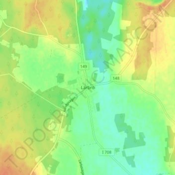
Name: Lärbro topographic map, elevation, terrain.
Location: Lärbro, Gotlands kommun, Gotlands län, 624 52, Sverige (57.76516 18.77064 57.80516 18.81064)
Average elevation: 22 m
Minimum elevation: 6 m
Maximum elevation: 39 m
Thank you for supporting this site ❤️
Make a donation
Make a donation
Other topographic maps
Click on a map to view its topography, its elevation and its terrain.