
Thank you for supporting this site ❤️
Make a donation
Make a donation
Volcán El Tromen topographic map
Click on the map to display elevation.
Thank you for supporting this site ❤️
Make a donation
Make a donation
About this map
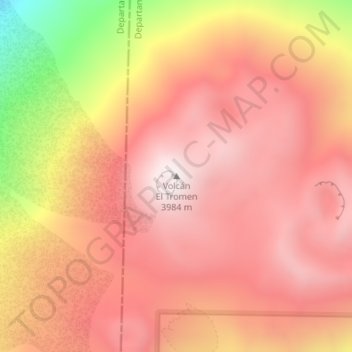
Name: Volcán El Tromen topographic map, elevation, terrain.
Average elevation: 3,623 m
Minimum elevation: 2,872 m
Maximum elevation: 3,979 m
Thank you for supporting this site ❤️
Make a donation
Make a donation
Other topographic maps
Click on a map to view its topography, its elevation and its terrain.
Municipio de San Martín de los Andes
Argentinien > Provinz Neuquén > Municipio de San Martín de los Andes
Average elevation: 1,135 m
Thank you for supporting this site ❤️
Make a donation
Make a donation