
Thank you for supporting this site ❤️
Make a donation
Make a donation
Merauke topographic map
Click on the map to display elevation.
Thank you for supporting this site ❤️
Make a donation
Make a donation
About this map
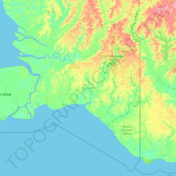
Name: Merauke topographic map, elevation, terrain.
Location: Merauke, South Papua, Western New Guinea, Indonesia (-9.12742 137.64060 -6.45803 141.01944)
Average elevation: 11 m
Minimum elevation: -2 m
Maximum elevation: 82 m
Thank you for supporting this site ❤️
Make a donation
Make a donation
Other topographic maps
Click on a map to view its topography, its elevation and its terrain.