
Thank you for supporting this site ❤️
Make a donation
Make a donation
Dağbeli topographic map
Click on the map to display elevation.
Thank you for supporting this site ❤️
Make a donation
Make a donation
About this map
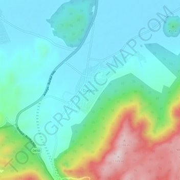
Name: Dağbeli topographic map, elevation, terrain.
Location: Dağbeli, Döşemealtı, Antalya, Mediterranean Region, Turkey (37.17226 30.48447 37.21226 30.52447)
Average elevation: 883 m
Minimum elevation: 773 m
Maximum elevation: 1,203 m
Thank you for supporting this site ❤️
Make a donation
Make a donation
Other topographic maps
Click on a map to view its topography, its elevation and its terrain.
Gulluk Mountain National Park
The national park, with an elevation difference of 250–1,665 m (820–5,463 ft), hosts a rich flora and fauna as well as historical values. The region is the habitat of the fallow deer, which is an extinct endangered species. It is also home to mammals such as mountain goats, caracals, lynxes, stone martens,…
Average elevation: 599 m