
Thank you for supporting this site ❤️
Make a donation
Make a donation
Gröningen topographic map
Click on the map to display elevation.
Thank you for supporting this site ❤️
Make a donation
Make a donation
Gröningen
Das südliche Vorland erreicht an der Domburg 240 m, am Speckberg 195 m, an der Ferdinandshöhe 113 m und fällt bei Adersleben auf 94 m ab. Die Ausläufer des Huys flachen sich bis zum Lauf der Holtemme auf weniger als 100 m NN ab.
Thank you for supporting this site ❤️
Make a donation
Make a donation
About this map
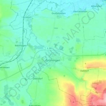
Name: Gröningen topographic map, elevation, terrain.
Location: Gröningen, Westliche Börde, Börde, Sachsen-Anhalt, Deutschland (51.89289 11.14991 51.99354 11.28734)
Average elevation: 106 m
Minimum elevation: 76 m
Maximum elevation: 218 m
Thank you for supporting this site ❤️
Make a donation
Make a donation