
Thank you for supporting this site ❤️
Make a donation
Make a donation
Wilhelmshaven topographic map
Click on the map to display elevation.
Thank you for supporting this site ❤️
Make a donation
Make a donation
About this map
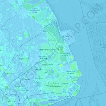
Name: Wilhelmshaven topographic map, elevation, terrain.
Location: Wilhelmshaven, Lower Saxony, Germany (53.50210 7.99356 53.63829 8.17106)
Average elevation: 0 m
Minimum elevation: -5 m
Maximum elevation: 16 m
Thank you for supporting this site ❤️
Make a donation
Make a donation
Other topographic maps
Click on a map to view its topography, its elevation and its terrain.