
Make a donation
Moișa topographic map
Click on the map to display elevation.
Make a donation
About this map
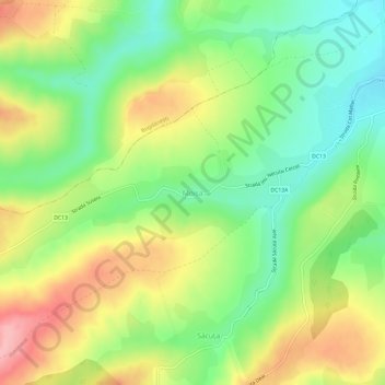
Name: Moișa topographic map, elevation, terrain.
Location: Moișa, Boroaia, Suceava, 727043, Romania (47.31257 26.26703 47.35257 26.30703)
Average elevation: 413 m
Minimum elevation: 354 m
Maximum elevation: 491 m
Make a donation
Other topographic maps
Click on a map to view its topography, its elevation and its terrain.
Make a donation
Gura Humorului
Gura Humorului is located in the north-eastern part of Romania, in southern Bukovina. The town is situated at the eastern limit of Obcinele Bucovinei Mountains, in Humorului Depression, at the confluence of Moldova River and Humor River. The average altitude of the town is 470 metres (1,540 ft). The European…
Average elevation: 644 m
Make a donation
Make a donation
Make a donation
Rădăuți
Rădăuți is situated in Bukovina, on a plain between the Suceava and Sucevița rivers, 37 km (23 mi) northwest from Suceava, the county capital. The city is located in the depression with the same name, at 375 metres (410 yards) altitude. It is one of the oldest settlements in Moldavia, known since the 15th…
Average elevation: 374 m
Make a donation
Make a donation
Make a donation