
Nelson County topographic map
Interactive map
Click on the map to display elevation.
About this map
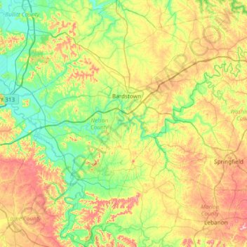
Name: Nelson County topographic map, elevation, terrain.
Location: Nelson County, Kentucky, United States (37.52277 -85.74251 37.99056 -85.15064)
Average elevation: 207 m
Minimum elevation: 127 m
Maximum elevation: 352 m
Other topographic maps
Click on a map to view its topography, its elevation and its terrain.
Hollywood
United States > Kentucky > Fayette County > Lexington > Hollywood
Hollywood, Lexington, Fayette County, Kentucky, 40502, United States
Average elevation: 308 m
Grayson County
Grayson County, Kentucky, United States
Average elevation: 196 m
Nelse
United States > Kentucky > Nelse
Nelse, Pike County, Kentucky, 41562, United States
Average elevation: 315 m
Elliott County
Elliott County, Kentucky, United States
Average elevation: 278 m