
Thank you for supporting this site ❤️
Make a donation
Make a donation
Ribble Valley topographic map
Click on the map to display elevation.
Thank you for supporting this site ❤️
Make a donation
Make a donation
About this map
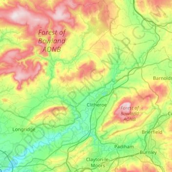
Name: Ribble Valley topographic map, elevation, terrain.
Location: Ribble Valley, Lancashire, England, United Kingdom (53.75620 -2.65083 54.04908 -2.18452)
Average elevation: 200 m
Minimum elevation: 9 m
Maximum elevation: 562 m
Thank you for supporting this site ❤️
Make a donation
Make a donation
Other topographic maps
Click on a map to view its topography, its elevation and its terrain.
Bury Hey Wood
United Kingdom > England > Lancashire > West Lancashire > Appley Bridge > Robin Hood
Average elevation: 106 m