
Make a donation
Bandung City topographic map
Click on the map to display elevation.
Make a donation
Bandung City
Bandung (Sundanese: ᮊᮧᮒ ᮘᮔ᮪ᮓᮥᮀ, romanized: Kota Bandung, pronounced [ˈbandʊŋ]; /ˈbɑːndʊŋ/) is the capital city of West Java province of Indonesia. Located on the island of Java, Greater Bandung (Bandung Basin Metropolitan Area / BBMA) is the country's second-largest and most populous metropolitan area, with over 11 million inhabitants. Situated 768 meters (2,520 feet) above sea level, the highest point in the North area with an altitude of 1,050 meters (3,445 feet) and the lowest in the South is 675 meters (2,215 feet) above sea level, approximately 140 kilometres (87 miles) southeast of Jakarta, Bandung has cooler year-round temperatures than most other Indonesian cities. The city lies on a river basin surrounded by volcanic mountains that provide a natural defence system, which was the primary reason for the Dutch East Indies government's plan to move the capital from Batavia (modern-day Jakarta) to Bandung.
Make a donation
About this map
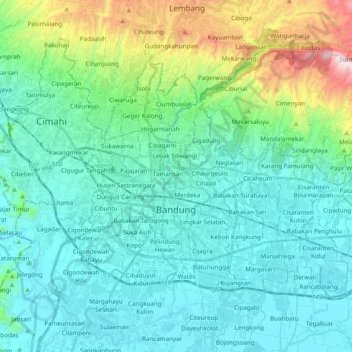
Name: Bandung City topographic map, elevation, terrain.
Location: Bandung City, West Java, Java, Indonesia (-6.96975 107.54536 -6.83685 107.73952)
Average elevation: 830 m
Minimum elevation: 643 m
Maximum elevation: 1,634 m
Make a donation
Other topographic maps
Click on a map to view its topography, its elevation and its terrain.
Make a donation
Make a donation
Make a donation
Make a donation
Make a donation
Make a donation
Make a donation
Bekasi
The City of Bekasi is a part of the Bekasi river basin, located in the downstream area of the basin with slopes ranging from 0 to 2% and elevations between 11 meters to 81 meters above sea level. This topographical condition leads to frequent flooding in many areas of Bekasi, especially during the rainy…
Average elevation: 23 m
Make a donation
Make a donation
Make a donation
Make a donation
DUSUN IV DESA MUKAPAYUNG KEC. CILILIN KAB. BANDUNG BARAT
Indonesia > West Java > West Bandung
Average elevation: 918 m
Make a donation
Make a donation
Make a donation
Make a donation
Make a donation
Make a donation
Make a donation
Make a donation
Make a donation
Make a donation
Ngamprah
Indonesia > West Java > West Bandung
Ngamprah has an elevation moderated tropical rainforest climate (Af) with moderate rainfall from June to September and heavy rainfall from October to May.
Average elevation: 803 m
Make a donation
Megamendung
Much of the district lies at an elevation of 500-600 metres, which moderates the temperature, and causing contrast to the heat of Greater Jakarta and other adjacent low-lying lands. Though much of the built-up area is not necessarily on rugged terrain, uneven ground is the most common terrain as it stands…
Average elevation: 776 m
Ngamprah
Indonesia > West Java > West Bandung
Ngamprah has an elevation moderated tropical rainforest climate (Af) with moderate rainfall from June to September and heavy rainfall from October to May.
Average elevation: 803 m
Make a donation
Make a donation
Mount Salak
Mount Salak is popular for many mountain climbing clubs, especially Route II, because of the difficulty involved in reaching the peak. Climbers bring water with them, especially through Post I at Kawah Ratu Route. A water source, supplied by rain, exists at an altitude of 2,211 m (7,254 ft) on this route.
Average elevation: 1,770 m
Make a donation