
Make a donation
Primorsky Krai topographic map
Click on the map to display elevation.
Make a donation
Primorsky Krai
Highlands dominate the territory of the krai. Most of the territory is mountainous, and almost 80% of it is forested. The average elevation is about 500 meters (1,640 ft). Sikhote-Alin is a mountainous formation, extending for the most part of the Krai. It consists of a number of parallel ranges: the Partizansky (Partisan), the Siny (Blue), the Kholodny (Cold), and others. There are many karst caves in the south of Primorye, including the relatively accessible Spyashchaya Krasavitsa cave (the Sleeping Beauty) in the Ussuriysky Nature Preserve. There are comparatively well-preserved fragments of ancient volcanoes in the area.
Make a donation
About this map
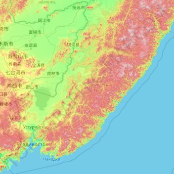
Name: Primorsky Krai topographic map, elevation, terrain.
Location: Primorsky Krai, Far Eastern Federal District, Russia (42.12271 130.39465 48.46524 139.30939)
Average elevation: 237 m
Minimum elevation: -2 m
Maximum elevation: 1,725 m
Make a donation
Other topographic maps
Click on a map to view its topography, its elevation and its terrain.
Make a donation
Тагил
Russia > Sverdlovsk Oblast > городской округ Нижний Тагил > Nizhny Tagil
Average elevation: 203 m
Make a donation
Make a donation
Make a donation
Make a donation
Make a donation
Make a donation
Make a donation