
Shelby County topographic map
Interactive map
Click on the map to display elevation.
About this map
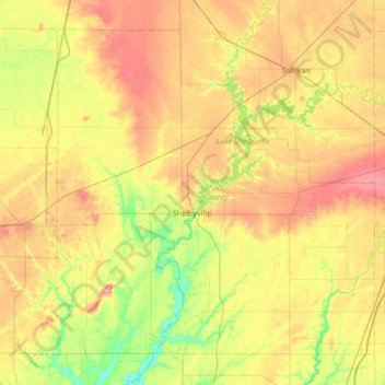
Name: Shelby County topographic map, elevation, terrain.
Location: Shelby County, Illinois, USA (39.21408 -89.14197 39.65359 -88.47038)
Average elevation: 196 m
Minimum elevation: 154 m
Maximum elevation: 247 m
Other topographic maps
Click on a map to view its topography, its elevation and its terrain.
Highland Park
USA > Illinois > Highland Park
Highland Park, Lake County, Illinois, 60035, USA
Average elevation: 194 m
Mount Prospect
USA > Illinois > Mount Prospect
Mount Prospect, Cook County, Illinois, USA
Average elevation: 205 m
Montague Island
Montague Island, Rockford, Winnebago County, Illinois, 61104, USA
Average elevation: 254 m