
Thank you for supporting this site ❤️
Make a donation
Make a donation
Fleinvær topographic map
Click on the map to display elevation.
Thank you for supporting this site ❤️
Make a donation
Make a donation
About this map
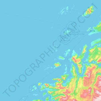
Name: Fleinvær topographic map, elevation, terrain.
Location: Fleinvær, Gildeskål, Nordland, Norway (66.83704 13.37719 67.47704 14.01719)
Average elevation: 83 m
Minimum elevation: -2 m
Maximum elevation: 1,337 m
Thank you for supporting this site ❤️
Make a donation
Make a donation
Other topographic maps
Click on a map to view its topography, its elevation and its terrain.
Thank you for supporting this site ❤️
Make a donation
Make a donation
Thank you for supporting this site ❤️
Make a donation
Make a donation