
Make a donation
New Caledonia topographic map
Click on the map to display elevation.
Make a donation
New Caledonia
The Diahot River is the longest river of New Caledonia, flowing for some 100 kilometres (62 mi). It has a catchment area of 620 km2 (240 sq mi) and opens north-westward into the Baie d'Harcourt, flowing towards the northern point of the island along the western escarpment of the Mount Panié. Most of the island is covered by wet evergreen forests, while savannahs dominate the lower elevations. The New Caledonian lagoon, with a total area of 24,000 square kilometres (9,300 sq mi) is one of the largest lagoons in the world. The lagoon and the surrounding New Caledonia Barrier Reef was named a UNESCO World Heritage Site in 2008 for its exceptional beauty and marine biodiversity.
Make a donation
About this map
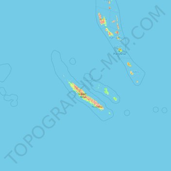
Name: New Caledonia topographic map, elevation, terrain.
Location: New Caledonia, France (-23.22175 157.98475 -17.68686 172.30572)
Average elevation: 4 m
Minimum elevation: 0 m
Maximum elevation: 1,380 m
Make a donation
Other topographic maps
Click on a map to view its topography, its elevation and its terrain.
Val Thorens
France > Auvergne-Rhône-Alpes > Savoy
Val Thorens ([val tɔʁɑ̃]) is a ski town in the Tarentaise Valley in the French Alps at an altitude of 2,300 m (7,500 ft). It is located in the commune of Saint-Martin-de-Belleville in the Savoie department. The resort forms part of the Les Trois Vallées ski area which, with over 600 km of slopes, is one…
Average elevation: 2,516 m
Make a donation
La Fageole
France > Nouvelle-Aquitaine > Dordogne > Saint-Félix-de-Reillac-et-Mortemart
Average elevation: 213 m
Make a donation
Beauregard
France > Bourgogne – Franche-Comté > Nièvre > Saint-Amand-en-Puisaye
Average elevation: 220 m
Make a donation
Lavillemichel
France > Nouvelle-Aquitaine > Haute-Vienne > Bessines-sur-Gartempe
Average elevation: 349 m
Make a donation
Make a donation
Laudibertie
France > Nouvelle-Aquitaine > Dordogne > Saint-Privat-en-Périgord > Festalemps
Average elevation: 93 m
Make a donation
Les Gardes
France > Auvergne-Rhône-Alpes > Cantal > Saint-Jacques-des-Blats
Average elevation: 1,266 m
Make a donation
Make a donation
Paris
Paris in its early history had only the rivers Seine and Bièvre for water. From 1809, the Canal de l'Ourcq provided Paris with water from less-polluted rivers to the north-east of the capital. From 1857, the civil engineer Eugène Belgrand, under Napoleon III, oversaw the construction of a series of new…
Average elevation: 75 m
Make a donation