
Make a donation
Les Cossardières topographic map
Click on the map to display elevation.
Make a donation
About this map
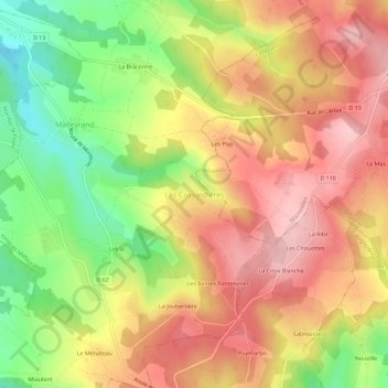
Name: Les Cossardières topographic map, elevation, terrain.
Average elevation: 245 m
Minimum elevation: 140 m
Maximum elevation: 327 m
Make a donation
Other topographic maps
Click on a map to view its topography, its elevation and its terrain.
Make a donation
Aubeterre-sur-Dronne
France > Nouvelle-Aquitaine > Charente
The highest point of the commune is at an altitude of 111m and is located on the plateau near the northern boundary. The lowest point is 38m located on the southern boundary next to the Dronne. The commune is spread between the valley of the Dronne and the top of the hill.
Average elevation: 60 m
Make a donation
Angoulême
France > Nouvelle-Aquitaine > Charente
The earliest Cretaceous period - the Cenomanian- is in the relatively low areas (l'Houmeau, the heights of Saint-Cybard, Sillac), at an average altitude of 50m.
Average elevation: 72 m
Make a donation
Angoulême
France > Nouvelle-Aquitaine > Charente
The earliest Cretaceous period - the Cenomanian- is in the relatively low areas (l'Houmeau, the heights of Saint-Cybard, Sillac), at an average altitude of 50m.
Average elevation: 72 m
Make a donation
La Rochefoucauld
France > Nouvelle-Aquitaine > Charente > La Rochefoucauld-en-Angoumois
Average elevation: 101 m
Make a donation
Angoulême
France > Nouvelle-Aquitaine > Charente
The earliest Cretaceous period - the Cenomanian- is in the relatively low areas (l'Houmeau, the heights of Saint-Cybard, Sillac), at an average altitude of 50m.
Average elevation: 72 m
Make a donation
Angoulême
France > Nouvelle-Aquitaine > Charente
The earliest Cretaceous period - the Cenomanian- is in the relatively low areas (l'Houmeau, the heights of Saint-Cybard, Sillac), at an average altitude of 50m.
Average elevation: 72 m
Make a donation
Make a donation
Make a donation
Make a donation
Make a donation
Make a donation
Make a donation
Make a donation
Make a donation