
Make a donation
Weißenstein topographic map
Click on the map to display elevation.
Make a donation
About this map
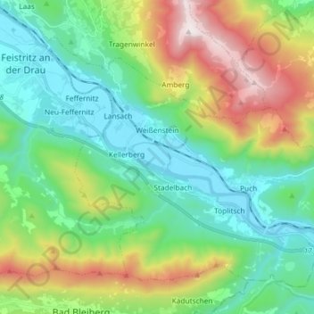
Name: Weißenstein topographic map, elevation, terrain.
Location: Weißenstein, Bezirk Villach-Land, Kärnten, 9721, Österreich (46.63267 13.66291 46.71513 13.80869)
Average elevation: 916 m
Minimum elevation: 494 m
Maximum elevation: 1,897 m
Make a donation
Other topographic maps
Click on a map to view its topography, its elevation and its terrain.
Rajach
Österreich > Kärnten > Bezirk Villach-Land > Velden am Wörther See > Lind ob Velden
Average elevation: 551 m
Make a donation
Maria Elend
Österreich > Kärnten > Bezirk Villach-Land > St. Jakob im Rosental
Average elevation: 585 m
Mittagskogel
Österreich > Kärnten > Bezirk Villach-Land > Finkenstein am Faaker See
Der Mittagskogel, slowenisch Kepa (kärntner-slowenisch Jepa), ist mit einer Höhe von 2145 m ü. A. einer der höchsten Berge der westlichen Karawanken. Er liegt an der österreichisch-slowenischen Grenze.
Average elevation: 1,574 m
Make a donation
Kärntner Törl
Österreich > Kärnten > Bezirk Villach-Land > St. Jakob im Rosental
Average elevation: 1,456 m
Make a donation
Göriach
Österreich > Kärnten > Bezirk Villach-Land > Velden am Wörther See > Kranzlhofen > Göriach
Average elevation: 587 m
Neufeld
Österreich > Kärnten > Bezirk Villach-Land > Finkenstein am Faaker See > Techanting
Average elevation: 579 m
Make a donation
Lerchbach
Österreich > Kärnten > Bezirk Villach-Land > Bad Bleiberg > Bleiberg-Kreuth
Average elevation: 1,000 m
Make a donation