
Town of Arietta topographic map
Interactive map
Click on the map to display elevation.
About this map
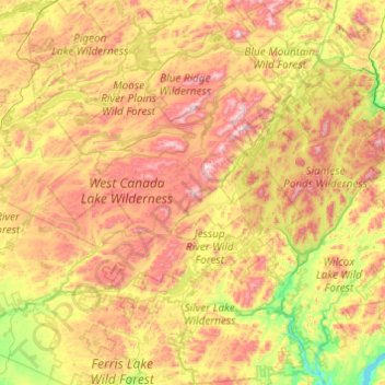
Name: Town of Arietta topographic map, elevation, terrain.
Location: Town of Arietta, Hamilton County, New York, United States (43.22823 -74.70538 43.93345 -74.45770)
Average elevation: 599 m
Minimum elevation: 227 m
Maximum elevation: 1,159 m
Other topographic maps
Click on a map to view its topography, its elevation and its terrain.
Hoffmeister
United States > New York > Hamilton County
Hoffmeister, Town of Morehouse, Hamilton County, New York, 13353, United States
Average elevation: 601 m