
Thank you for supporting this site ❤️
Make a donation
Make a donation
Aras de los Olmos topographic map
Click on the map to display elevation.
Thank you for supporting this site ❤️
Make a donation
Make a donation
Aras de los Olmos
The climate: due to its altitude, this land has cold winters and hot summers, although with mild nights. The snow can sometimes be seen, forming beautiful landscapes.
Thank you for supporting this site ❤️
Make a donation
Make a donation
About this map
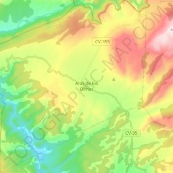
Name: Aras de los Olmos topographic map, elevation, terrain.
Average elevation: 967 m
Minimum elevation: 574 m
Maximum elevation: 1,545 m
Thank you for supporting this site ❤️
Make a donation
Make a donation
Other topographic maps
Click on a map to view its topography, its elevation and its terrain.