
Thank you for supporting this site ❤️
Make a donation
Make a donation
Würzburg topographic map
Click on the map to display elevation.
Thank you for supporting this site ❤️
Make a donation
Make a donation
Würzburg
Würzburg covers an area of 87.6 square kilometres and lies at an altitude of around 177 metres.
Thank you for supporting this site ❤️
Make a donation
Make a donation
About this map
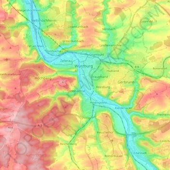
Name: Würzburg topographic map, elevation, terrain.
Location: Würzburg, Bavaria, Germany (49.71068 9.87163 49.84546 10.01443)
Average elevation: 270 m
Minimum elevation: 166 m
Maximum elevation: 385 m
Thank you for supporting this site ❤️
Make a donation
Make a donation
Other topographic maps
Click on a map to view its topography, its elevation and its terrain.