
Thank you for supporting this site ❤️
Make a donation
Make a donation
Ta’ Dmejrek topographic map
Click on the map to display elevation.
Thank you for supporting this site ❤️
Make a donation
Make a donation
Ta’ Dmejrek
Ta' Dmejrek is the highest point of Malta, located on the Dingli Cliffs, with an elevation of 253 metres (830 ft) above sea level.
Thank you for supporting this site ❤️
Make a donation
Make a donation
About this map
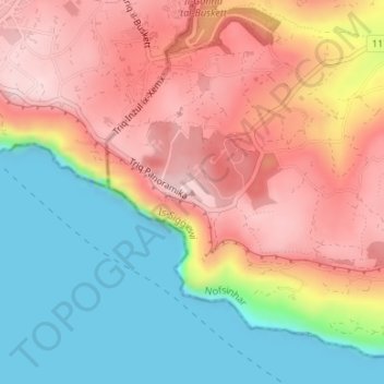
Name: Ta’ Dmejrek topographic map, elevation, terrain.
Location: Ta’ Dmejrek, Siġġiewi, Southern Region, DGL 1942, Malta (35.84565 14.39696 35.84575 14.39706)
Average elevation: 130 m
Minimum elevation: 0 m
Maximum elevation: 252 m
Thank you for supporting this site ❤️
Make a donation
Make a donation