
Cretas topographic map
Interactive map
Click on the map to display elevation.
About this map
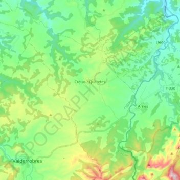
Name: Cretas topographic map, elevation, terrain.
Location: Cretas, Matarraña / Matarranya, Teruel, Aragón, 44623, Spanje (40.85999 0.11593 40.98435 0.25559)
Average elevation: 533 m
Minimum elevation: 372 m
Maximum elevation: 951 m
Other topographic maps
Click on a map to view its topography, its elevation and its terrain.
Valderrobres / Vall de Roures
Spanje > Aragón > Matarraña / Matarranya
Valderrobres / Vall de Roures, Matarraña / Matarranya, Teruel, Aragón, 44580, Spanje
Average elevation: 744 m