
Thank you for supporting this site ❤️
Make a donation
Make a donation
Barrow Gurney topographic map
Click on the map to display elevation.
Thank you for supporting this site ❤️
Make a donation
Make a donation
About this map
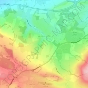
Name: Barrow Gurney topographic map, elevation, terrain.
Location: Barrow Gurney, North Somerset, England, United Kingdom (51.39140 -2.70805 51.42071 -2.65394)
Average elevation: 115 m
Minimum elevation: 33 m
Maximum elevation: 218 m
Thank you for supporting this site ❤️
Make a donation
Make a donation
Other topographic maps
Click on a map to view its topography, its elevation and its terrain.
Weston-super-Mare
United Kingdom > England > North Somerset > Weston-super-Mare
Average elevation: 13 m
Thank you for supporting this site ❤️
Make a donation
Make a donation
Thank you for supporting this site ❤️
Make a donation
Make a donation
Thank you for supporting this site ❤️
Make a donation
Make a donation
Thank you for supporting this site ❤️
Make a donation
Make a donation
Portishead Quays Marina
United Kingdom > England > North Somerset > Portishead > North Weston
Average elevation: 11 m
Thank you for supporting this site ❤️
Make a donation
Make a donation
Thank you for supporting this site ❤️
Make a donation
Make a donation
Thank you for supporting this site ❤️
Make a donation
Make a donation
Thank you for supporting this site ❤️
Make a donation
Make a donation
Thank you for supporting this site ❤️
Make a donation
Make a donation