
Thank you for supporting this site ❤️
Make a donation
Make a donation
Chabrière topographic map
Click on the map to display elevation.
Thank you for supporting this site ❤️
Make a donation
Make a donation
About this map
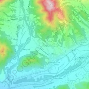
Name: Chabrière topographic map, elevation, terrain.
Average elevation: 568 m
Minimum elevation: 471 m
Maximum elevation: 889 m
Thank you for supporting this site ❤️
Make a donation
Make a donation
Other topographic maps
Click on a map to view its topography, its elevation and its terrain.
04510
France > Provence-Alpes-Côte d'Azur > Alpes-de-Haute-Provence > Mallemoisson - Les Grillons > Saint-Pons
Average elevation: 683 m