
Thank you for supporting this site ❤️
Make a donation
Make a donation
Gônoy topographic map
Click on the map to display elevation.
Thank you for supporting this site ❤️
Make a donation
Make a donation
About this map
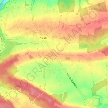
Name: Gônoy topographic map, elevation, terrain.
Location: Gônoy, Saint-Gérard, Mettet, Namur, Wallonie, Belgique (50.34733 4.69169 50.38733 4.73169)
Average elevation: 245 m
Minimum elevation: 196 m
Maximum elevation: 276 m
Thank you for supporting this site ❤️
Make a donation
Make a donation
Other topographic maps
Click on a map to view its topography, its elevation and its terrain.