
Make a donation
Córdoba topographic map
Click on the map to display elevation.
Make a donation
Córdoba
The differences in elevation in the Valley are very small, ranging from 100 and 170 metres above sea level, with the city proper located at an average altitude of roughly 125 metres above sea level. The landscape of the valley is further subdivided in the piedmont connecting with the Sierra, the fluvial terraces and the most immediate vicinity of the river course.
Make a donation
About this map
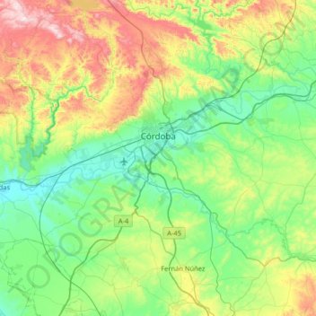
Name: Córdoba topographic map, elevation, terrain.
Location: Córdoba, Andalusia, Spain (37.66582 -4.99860 38.03152 -4.35143)
Average elevation: 281 m
Minimum elevation: 64 m
Maximum elevation: 878 m
Make a donation
Other topographic maps
Click on a map to view its topography, its elevation and its terrain.
Make a donation
Alhambra
Spain > Andalusia > Partido Judicial de Granada > Granada
During the reign of the Nasrid Dynasty, the Alhambra was transformed into a palatine city, complete with an irrigation system composed of aqueducts and water channels that provided water for the complex and for other nearby countryside palaces such as the Generalife. Previously, the old fortresses on the hill…
Average elevation: 759 m
Peñon de Bodíjar
Spain > Andalusia > Comarca de la Costa Granadina > Los Guájares
Average elevation: 870 m
Make a donation
Cortijo ruinas
Spain > Andalusia > Comarca de la Alpujarra Granadina > Capileira
Average elevation: 2,246 m
Poblado de Doña Blanca
Spain > Andalusia > Bay of Cádiz > El Puerto de Santa María
Average elevation: 13 m
Make a donation
Make a donation
El Encinarillo
Spain > Andalusia > Comarca de la Alpujarra Granadina > Válor
Average elevation: 1,717 m
Make a donation
Make a donation
Make a donation
Sierra de la Huerta del Abad
Spain > Andalusia > Sierra de Huelva > Aracena > Carboneras
Average elevation: 525 m
Make a donation
Make a donation
Iglesia de Nuestra Señora Gracia
Spain > Andalusia > Partido Judicial de Guadix > Guadix
Average elevation: 959 m
Make a donation
Make a donation
Make a donation
Cortijo de Vegueta
Spain > Andalusia > Comarca de la Costa Granadina > Almuñécar
Average elevation: 211 m
Make a donation
Make a donation
Maroma
Spain > Andalusia > La Axarquía > Canillas de Aceituno
La Maroma, also known as Tejeda, at an altitude of 2069 m, is the highest peak of the Sierra de Tejeda, Penibaetic System, Spain. The summit is located in the region of Axarquía on the border between the provinces of Granada and Málaga.
Average elevation: 1,706 m
Make a donation
Alhambra
Spain > Andalusia > Partido Judicial de Granada > Granada
During the reign of the Nasrid Dynasty, the Alhambra was transformed into a palatine city, complete with an irrigation system composed of aqueducts and water channels that provided water for the complex and for other nearby countryside palaces such as the Generalife. Previously, the old fortresses on the hill…
Average elevation: 759 m
Make a donation
Make a donation
Guájar Faragüit
Spain > Andalusia > Partido Judicial de Motril > Los Guájares
Average elevation: 502 m
Make a donation
Make a donation
Make a donation
Puero de Jeres
Spain > Andalusia > Comarca de Guadix > Jérez del Marquesado
Average elevation: 2,671 m
Make a donation
Make a donation
Make a donation
Sierra Nevada
Spain > Andalusia > Comarca de la Alpujarra Granadina > Lanjarón
Average elevation: 2,223 m
Jardines del Triunfo
Spain > Andalusia > Comarca de la Vega de Granada > Granada
Average elevation: 719 m
Make a donation
Pinar de los Guisos
Spain > Andalusia > Bay of Cádiz > Chiclana de la Frontera
Average elevation: 18 m
Parque Natural Sierra de Tejeda, Almijara y Alhama
Spain > Andalusia > Comarca de Alhama
Average elevation: 754 m
Make a donation