
Thank you for supporting this site ❤️
Make a donation
Make a donation
Sparta Township topographic map
Click on the map to display elevation.
Thank you for supporting this site ❤️
Make a donation
Make a donation
About this map
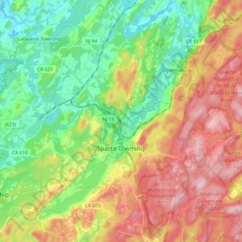
Name: Sparta Township topographic map, elevation, terrain.
Location: Sparta Township, Sussex County, New Jersey, United States (40.99005 -74.68853 41.11869 -74.53581)
Average elevation: 265 m
Minimum elevation: 149 m
Maximum elevation: 426 m
Thank you for supporting this site ❤️
Make a donation
Make a donation
Other topographic maps
Click on a map to view its topography, its elevation and its terrain.