
Make a donation
Municipality of Kalamata topographic map
Click on the map to display elevation.
Make a donation
About this map
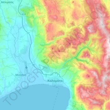
Name: Municipality of Kalamata topographic map, elevation, terrain.
Average elevation: 490 m
Minimum elevation: -3 m
Maximum elevation: 1,606 m
Make a donation
Other topographic maps
Click on a map to view its topography, its elevation and its terrain.
Pylos
Greece > Peloponnese Region > Messenia Regional Unit
The erection of this fort led to one of the most memorable events in the Peloponnesian War. Thucydides has given a minute account of the topography of the district, which, though clear and consistent with itself, does not coincide, in all points, with the existing locality, Thucydides describes the harbour, of…
Average elevation: 79 m
Αβία
Greece > Peloponnese Region > Messenia Regional Unit > Municipal Unit of Avia
Average elevation: 45 m
Stoupa
Greece > Peloponnese Region > Messenia Regional Unit > Municipal Unit of Lefktro
Average elevation: 63 m