
Make a donation
Republika Srpska topographic map
Click on the map to display elevation.
Make a donation
Republika Srpska
Republika Srpska covers 24,816.2 square kilometres (9,582 square miles), excluding the Brčko District, which is held in condominium by both entities, but is de facto sovereign within Bosnia and Herzegovina. Republika Srpska, if it were a country, would be 146th largest in the world. Elevation varies greatly, with Maglić, a peak in the Dinaric Alps near Montenegro, reaching 2,386 metres (7,828 ft), and parts nearer the Adriatic going down to sea level. The largest and most popular ski resort in Bosnia and Herzegovina is situated on the slopes of the mountain Jahorina, in the eastern part of the entity. Other major mountains in Republika Srpska include Volujak, Zelengora, Lelija, Lebršnik, Crvanj, Orjen, Klekovača, Vitorog, Kozara, Romanija, Treskavica and Trebević.
Make a donation
About this map
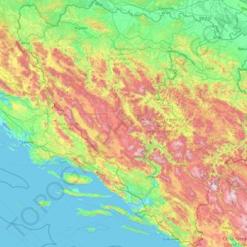
Name: Republika Srpska topographic map, elevation, terrain.
Location: Republika Srpska, Bosnia and Herzegovina (42.55531 16.20013 45.27641 19.62373)
Average elevation: 522 m
Minimum elevation: -4 m
Maximum elevation: 2,306 m
Make a donation