
Thank you for supporting this site ❤️
Make a donation
Make a donation
Puente Nacional topographic map
Click on the map to display elevation.
Thank you for supporting this site ❤️
Make a donation
Make a donation
About this map
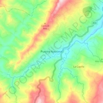
Name: Puente Nacional topographic map, elevation, terrain.
Location: Puente Nacional, Vélez, Santander, Colombia (5.83706 -73.71914 5.91706 -73.63914)
Average elevation: 1,745 m
Minimum elevation: 1,558 m
Maximum elevation: 2,047 m
Thank you for supporting this site ❤️
Make a donation
Make a donation