
Make a donation
Riohacha topographic map
Click on the map to display elevation.
Make a donation
About this map
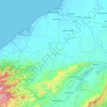
Name: Riohacha topographic map, elevation, terrain.
Location: Riohacha, La Guajira, Colombia (10.91072 -73.38560 11.56136 -72.60255)
Average elevation: 250 m
Minimum elevation: -4 m
Maximum elevation: 2,710 m
Make a donation
Other topographic maps
Click on a map to view its topography, its elevation and its terrain.
Maicao
Colombia > La Guajira > Maicao
The municipality of Maicao borders to the north with the municipalities of Uribia and Manaure; to the east with the Venezuela; to the south with the municipality of Albania and to the west with the municipality of Riohacha covering a total area of 1,782 km2 and at altitude over sea level of 52 m.
Average elevation: 51 m
Make a donation
Palomino
Colombia > La Guajira > Dibulla
Palomino is located in the municipality of Dibulla part of the department of Guajira and is only 2 meters above sea level. It is one of the five towns that form the municipality of Dibulla. It is located on the foothills of the Sierra Nevada Mountains of Colombia. The Sierra Nevada de Santa Marta, declared as…
Average elevation: 51 m