
Pará topographic map
Interactive map
Click on the map to display elevation.
About this map
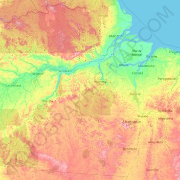
Name: Pará topographic map, elevation, terrain.
Location: Pará, North Region, Brazil (-9.83902 -58.89700 2.59093 -45.94340)
Average elevation: 176 m
Minimum elevation: -4 m
Maximum elevation: 800 m
Other topographic maps
Click on a map to view its topography, its elevation and its terrain.
Brasília
Brazil > Federal District > Região Integrada de Desenvolvimento do Distrito Federal e Entorno
The city sits at an elevation of 1,000 metres (3,300 ft) and more, high on the Brazilian Highlands in the country's center-western region. Paranoá Lake, a large artificial lake, was built to increase the amount of water available and to maintain the region's humidity. It has a marina, and hosts wakeboarders…
Average elevation: 1,084 m
Região Metropolitana do Recife
Brazil > Pernambuco > Região Metropolitana do Recife > Cabo de Santo Agostinho
Average elevation: 119 m