
Thank you for supporting this site ❤️
Make a donation
Make a donation
Hormozgan Province topographic map
Click on the map to display elevation.
Thank you for supporting this site ❤️
Make a donation
Make a donation
About this map
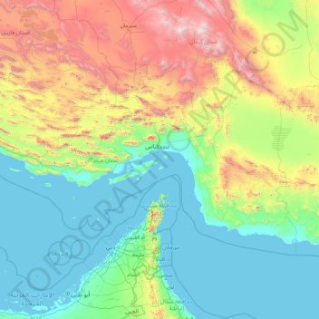
Name: Hormozgan Province topographic map, elevation, terrain.
Location: Hormozgan Province, Iran (25.19940 52.48240 28.79073 59.23577)
Average elevation: 666 m
Minimum elevation: -2 m
Maximum elevation: 4,196 m
Thank you for supporting this site ❤️
Make a donation
Make a donation
Other topographic maps
Click on a map to view its topography, its elevation and its terrain.
شورستان
Iran > South Khorasan Province > Sarbisheh County > دهستان مؤمن آباد
Average elevation: 1,912 m
Thank you for supporting this site ❤️
Make a donation
Make a donation
Thank you for supporting this site ❤️
Make a donation
Make a donation
Sarbisheh
Iran > South Khorasan Province > Sarbisheh County > دهستان مؤمن آباد
Average elevation: 1,860 m
Baba Jan, East Azerbaijan
Iran > East Azerbaijan Province > Ahar County > دهستان قشلاق
Average elevation: 1,752 m
Thank you for supporting this site ❤️
Make a donation
Make a donation
Pasak
Iran > Sistan and Baluchestan Province > Qasr-e-Ghand County > دهستان هیت > Pasak
Average elevation: 481 m
Thank you for supporting this site ❤️
Make a donation
Make a donation