
Make a donation
Guadalajara topographic map
Click on the map to display elevation.
Make a donation
Guadalajara
Under the Köppen climate classification, Guadalajara has a humid subtropical climate (Cwa), a temperate climate that is quite close to a tropical climate, featuring dry warm winters and wet, mildly hot summers. Guadalajara's climate is influenced by its high altitude and the general seasonality of precipitation patterns in western North America.
Make a donation
About this map
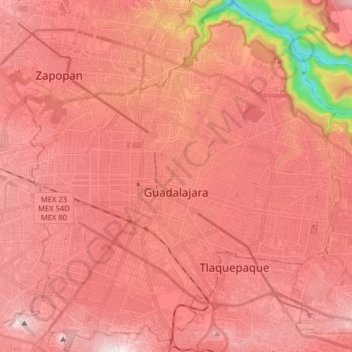
Name: Guadalajara topographic map, elevation, terrain.
Location: Guadalajara, Región Centro, Jalisco, Mexico (20.60374 -103.40706 20.75270 -103.26376)
Average elevation: 1,543 m
Minimum elevation: 981 m
Maximum elevation: 1,776 m
Make a donation
Other topographic maps
Click on a map to view its topography, its elevation and its terrain.
Puerto Vallarta
Mexico > Jalisco > Puerto Vallarta
In 1968, the Puerto Vallarta municipality was elevated to City status. The elevation in status reflected interest by Mexican federal and state governments in developing the Puerto Vallarta as an international resort destination. Puerto Vallarta has since also attracted a lively immigrant community from the…
Average elevation: 306 m