
Thank you for supporting this site ❤️
Make a donation
Make a donation
Georgia topographic map
Click on the map to display elevation.
Thank you for supporting this site ❤️
Make a donation
Make a donation
About this map
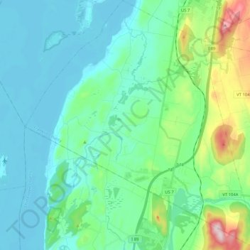
Name: Georgia topographic map, elevation, terrain.
Location: Georgia, Franklin County, Vermont, United States (44.65115 -73.22886 44.79634 -73.03807)
Average elevation: 106 m
Minimum elevation: 28 m
Maximum elevation: 435 m
Thank you for supporting this site ❤️
Make a donation
Make a donation
Other topographic maps
Click on a map to view its topography, its elevation and its terrain.
Thank you for supporting this site ❤️
Make a donation
Make a donation
Thank you for supporting this site ❤️
Make a donation
Make a donation
Sheldon Springs
United States > Vermont > Franklin County > Sheldon
Sheldon Springs is an unincorporated community village in the town of Sheldon in Franklin County, Vermont, United States. It lies at an altitude of 299 feet (91 m). A post office was established in 1871.
Average elevation: 118 m
Thank you for supporting this site ❤️
Make a donation
Make a donation