
Thank you for supporting this site ❤️
Make a donation
Make a donation
Dubí topographic map
Click on the map to display elevation.
Thank you for supporting this site ❤️
Make a donation
Make a donation
About this map
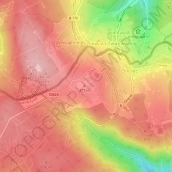
Name: Dubí topographic map, elevation, terrain.
Location: Dubí, okres Teplice, Ústecký kraj, Northwest, Czechia, Cinovec (50.72942 13.75778 50.72952 13.75788)
Average elevation: 839 m
Minimum elevation: 717 m
Maximum elevation: 895 m
Thank you for supporting this site ❤️
Make a donation
Make a donation
Other topographic maps
Click on a map to view its topography, its elevation and its terrain.
Thank you for supporting this site ❤️
Make a donation
Make a donation
Děčín
Czechia > Northwest > Ústecký kraj > Děčín
Děčín is located in northwestern Bohemia, at the confluence of the rivers Elbe and Ploučnice. The Elbe cut through the soft sandstone mountains of the region, and the city lies in the transition zone between Bohemian Switzerland and the Lusatian Mountains in the north and the Central Bohemian Uplands in…
Average elevation: 349 m