
Make a donation
Sosnowiec topographic map
Click on the map to display elevation.
Make a donation
Sosnowiec
For Sosnowiec's 100th birthday, the downtown area was thoroughly rebuilt, to harmonise its architectural layout and give the city a more modern image. In 2004 Sosnowiec authorities and designers were awarded the Grand Prix for the rebuilding of the downtown area in a competition for the best public space in the Śląskie Provinces. This investment had been accompanied by a program designed to improve the esthetic qualities of the city, under which a comprehensive program for unifying the colors of the elevations, and advertisements entitled “rainbow city” were introduced. Among the city districts there are.
Make a donation
About this map
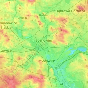
Name: Sosnowiec topographic map, elevation, terrain.
Location: Sosnowiec, Metropolis GZM, Silesian Voivodeship, Poland (50.22552 19.07131 50.31694 19.31795)
Average elevation: 272 m
Minimum elevation: 226 m
Maximum elevation: 347 m
Make a donation
Other topographic maps
Click on a map to view its topography, its elevation and its terrain.
Make a donation
Zwardoń
Poland > Silesian Voivodeship > Żywiec County
Zwardoń, located at the elevation of 690 meters above sea level, is placed between three mountain passes - Przysłop, Zwardońska and Graniczne. Until 1975, the village was administratively tied with Kraków and Lesser Poland. In 1975 - 1999, it belonged to Bielsko-Biala Voivodeship, and after the territorial…
Average elevation: 710 m
Młyńsko
Poland > Silesian Voivodeship > Żywiec County > Międzybrodzie Bialskie
Average elevation: 454 m
Make a donation
Make a donation
Make a donation
Strzyżowice - Biska
Poland > Silesian Voivodeship > Będzin County > Brzękowice-Wał
Average elevation: 333 m
Make a donation
Make a donation
Make a donation
Wilamowice
Poland > Silesian Voivodeship > Bielsko County > Wilamowice > Wilamowice
Average elevation: 273 m
Make a donation
Make a donation