
Thank you for supporting this site ❤️
Make a donation
Make a donation
Beethovenstraße topographic map
Click on the map to display elevation.
Thank you for supporting this site ❤️
Make a donation
Make a donation
About this map
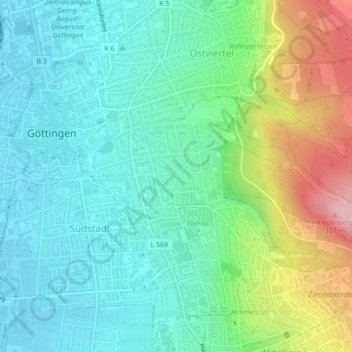
Name: Beethovenstraße topographic map, elevation, terrain.
Average elevation: 201 m
Minimum elevation: 148 m
Maximum elevation: 335 m
Thank you for supporting this site ❤️
Make a donation
Make a donation
Other topographic maps
Click on a map to view its topography, its elevation and its terrain.
Breslauer Straße 1
Deutschland > Niedersachsen > Landkreis Göttingen > Göttingen
Average elevation: 199 m
Stadtwald Göttingen und Kerstlingeröder Feld
Deutschland > Niedersachsen > Landkreis Göttingen > Göttingen
Average elevation: 340 m
Thank you for supporting this site ❤️
Make a donation
Make a donation
Astrid-Lindgren-Schule
Deutschland > Niedersachsen > Landkreis Göttingen > Göttingen
Average elevation: 173 m